Fiordland is high on any hiking/tramping bucket list for good reason – lush forests thanks to the high rainfall, massive glacier carved valleys, distinctive peaks scattered with tarns, and beautifully clear rivers and waterfalls.
New Zealand/Aotearoa has 10 premier hikes/tramps that are classified as “Great Walks”, and three of these – the Milford, Kepler and Routeburn tracks – are in Fiordland National Park. They each have different offerings in terms of distance, views and scenery, so it can be difficult trying to choose which ones to tackle. In this post I’m going to give a general overview of their offerings and share my subjective experiences to help you decide.
I won’t try to separate them based on the physicality as that’s subjective and can largely be determined by looking at their elevation profile and distances. The weather will play a big part in how enjoyable you find them (and my experiences below), but that comes with the territory of doing a bookable Great Walk where you have to deal with whatever weather you get dealt. It is possible to book at short notice if you are by yourself, but I wouldn’t rely on it. The Department of Conservation (DOC) website has an abundance of information on what to expect, distance, huts, booking etc and should be your first port of call when looking into them. Disclaimers aside, and in no particular order…
The Routeburn Track
Track overview & logistics
The Routeburn Track is 33km, with trailheads at the Routeburn Shelter near Glenorchy (an hour from Queenstown), and at the Divide Shelter, on the Milford Highway (an hour from Te Anau). Along the track there are three huts, two of which also have campsites nearby. It is typically completed in three days, staying at Routeburn Falls Hut and Lake Mackenzie Hut. From the Glenorchy end the track begins alongside a river in the beech forest, gradually climbing up to Routeburn Falls Hut.
Past here you leave the bushline on the climb up to Harris Saddle, with views back down the valley, past Lake Harris to the Valley of the Trolls, and can stop at the Harris Saddle Shelter for a rest and food. There is an optional steep walk up Conical Hill near the shelter, which gives fantastic 360 degree views if conditions allow.
Between the shelter and Lake Mackenzie Hut the track sidles along the side of the range, high above the Hollyford River, before dropping down to the lake. After Lake Mackenzie Hut you continue sidling along the range, mostly in the bush with some open areas, gradually descending to Lake Howden then a final short climb up around Key Summit before dropping to The Divide Shelter.
There is a 324km drive between trailheads, which can make logistics tricky if you have your own car or rental. Some options are to get a shuttle/bus to or from trailheads, use a car relocation service, or swap keys with another hiking/running party going the other way. Keen people looking to extend their tramp sometimes combine the Routeburn Track with the Greenstone – Caples Track, forming a rough loop. This makes the trailheads closer together but will still require some hitchhiking/car shuffling/shuttling to avoid a 28km walk along the road.


My experience
I walked the Routeburn with a group of friends in February 2020, with an additional night camping at Lake Wilson accessed via the Valley of the Trolls. We started at the Routeburn Shelter (Glenorchy side), stayed the first night at Routeburn Falls Hut, second night camping at Lake Wilson, third night at Lake Mackenzie Hut, and walked out on the fourth day. We had clear weather for the first two days, with some drizzle starting as we dropped to Mackenzie Hut on the third day then steady rain on the walk out. This meant we got fantastic views from Harris Saddle and Conical Hill, and a nice sunset from the campsite looking over to the Darran Mountains and Hollyford Valley.
On the last day we got to witness some of the impressive waterfalls on the track, at one stage having to use a detour track which was just a side stream as a waterfall was too powerful for us to walk past. Some of our group had walked the traditional three-day version and the same waterfall was barely flowing when they went past the day before! My scenic highlights were the views from Conical Hill, looking up Lake Mackenzie, and camping around Lake Wilson. While impressive, the view around Lake Harris was a bit bland due to the clear weather, and I’m sure a bit of atmospheric weather would add to the views.
A wildlife highlight of the Routeburn is the rock wren/tuke, which I hadn’t seen previously so was very excited to hear and see around the saddle and Lake Wilson. There were also steady forest birds heard and seen during the bush parts of the walk, particularly on the Fiordland side where donations at Lake Mackenzie Hut have contributed to an extensive trapping network, though the wet weather on the walk out wasn’t the best for birding.


The Kepler Track
Track overview & logistics
The Kepler Track is a 60km loop, starting and finishing at the Lake Te Anau control gates 5.5km from the centre of Te Anau. There is also an optional trailhead at nearby Rainbow Reach, which can be used to skip the 9.5km between Rainbow Reach and the control gate trailheads. Along the track there are three huts, with the middle hut (Iris Burn) also having a campsite. The track is typically walked in 3-4 days. Skipping the section between the trailheads makes it easier to complete in three days, staying at Luxmore Hut and Iris Burn Hut.
If you start at the control gates heading to Luxmore Hut, you’ll begin with a nice bush walk alongside the lake, before tackling steady but well formed switchbacks through the bush for several hours. Luxmore Hut is near the bushline and has views over the lake, to Murchison Mountains and over Te Anau and nearby farms. Once at Luxmore Hut most of the elevation has already been gained and you walk along the side of the range, with an optional side trip up Mt Luxmore. Eventually the track begins descending down to the Iris Burn valley, starting with some long staircases followed by switchbacks below the bushline. Iris Burn Hut is near the bottom of the spur that the track descends, with the river flowing nearby and an optional walk alongside the river to the waterfall at the head of the valley. From Iris Burn Hut to Moturau Hut is a flat, well graded walk down the valley through beech forest and the occasional sea of ferns. Moturau Hut is beside Lake Manapouri, with the track continuing through beech forest to the Rainbow Reach trailhead followed by control gate trailhead.


My experience
I walked the Kepler solo in February 2020, a couple days after completing the Routeburn Track. At the time I was tossing up between the Kepler and Milford but opted for the Kepler as it would give me more time to rest and wash gear after the Routeburn and was easier to arrange logistics. I booked a shuttle for pick up and drop off, beginning at control gates and getting picked up from Rainbow Reach. I stayed at Luxmore Hut and Iris Burn Hut, so did the walk in three days as opposed to the possible four.
The weather has a big influence on the views on the Kepler, if it’s raining or clagged in for the walk between Luxmore Hut and Iris Burn then you’ll miss all the views which are the main selling point of the hike. I had perfect clear weather on all days thankfully, though I found the mountain views much less inspiring than the Routeburn or Milford. On those tracks you get an immersive Fiordland experience, whereas on the Kepler you are on the edge of the park and looking out at the impressive mountains in the distance. The views back over expansive farmland also weren’t particularly to my liking, so I preferred the sections further in the national park. I also found the scenery not very variable, unlike the other great walks.
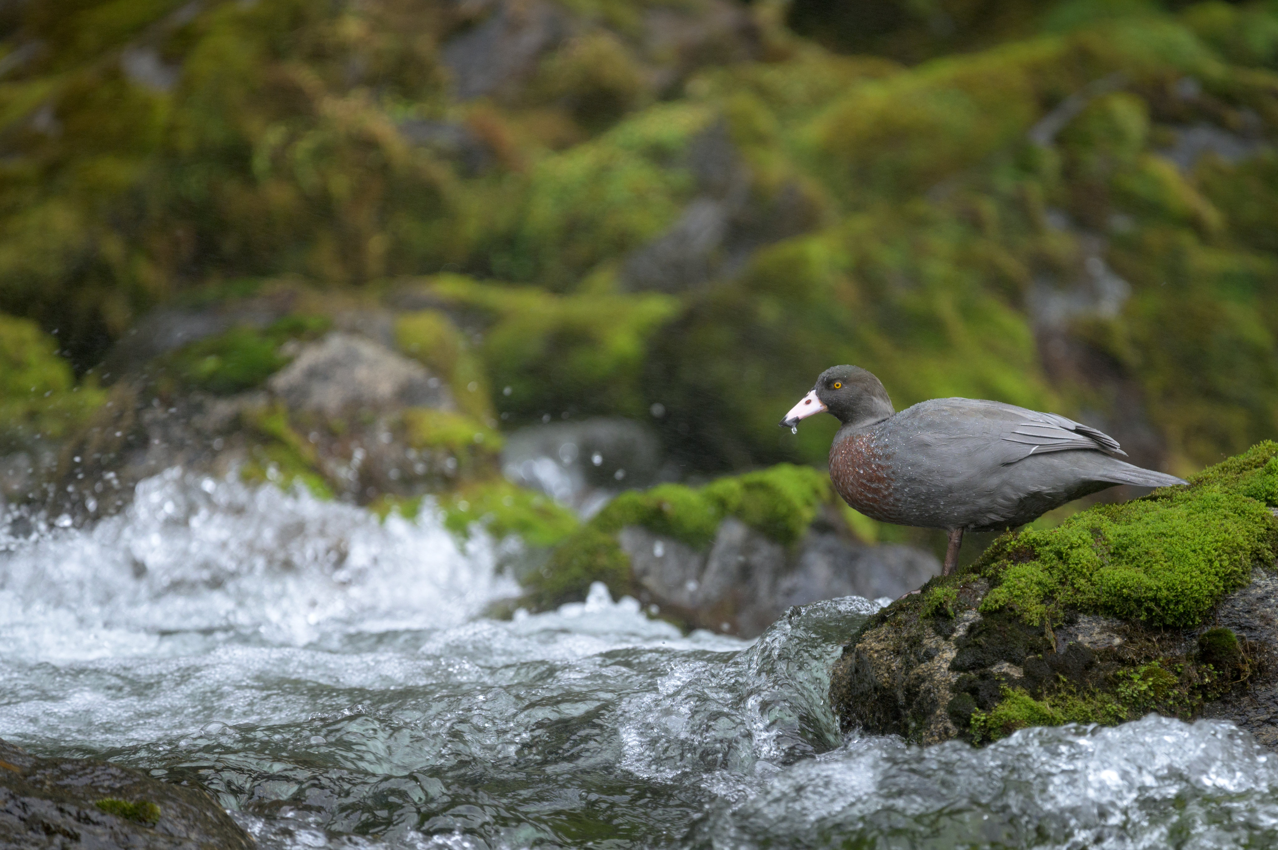
Iris Burn Hut is in a very nice location, looking up the steep glacial valley with a river nearby for a brisk swim. The campsite is near the hut and the river, but when I was there there were huge amounts of sandflies which kept most people inside. In the winter when there are less sandflies around it could be a pretty choice wee overnight trip from Rainbow Reach. I was pleasantly surprised by the wildlife on the Kepler, with plenty of forest birds on the walk up to Luxmore, thanks in part to community group trapping in the area, kea at the huts, whio/blue ducks in the river near Iris Burn, and kiwi heard at both Luxmore and Iris Burn. A lot of people went for a night walk at Iris Burn in the hope of seeing kiwi, and while we were unsuccessful another group had a fantastic close encounter.


The Milford Track
Track overview & logistics
The Milford Track is 53.5km long, starting at the head of Lake Te Anau (Glade Wharf) and finishing at Sandfly Point in Milford Sound. Boat transport is required to get to the start and get picked up at the end. The track can only be walked in one way, and you have to stay at all three huts on the way, which takes the thinking out of planning it and means you’ll be walking and sharing a hut with the same hikers each day/night.
The first “day” is a 5km flat walk through beech forest from Glade Wharf to Clinton Hut. The second day is a very gradual climb to the new Mintaro Hut, going alongside the Clinton River the whole way. Once at Mintaro Hut you have a view of Mackinnon Pass – at least if the weather is nice. If the weather is nice when you get to Mintaro, you still have plenty of daylight hours and energy, you couldhead up the pass to make sure you get views from the top to avoid missing out if the next days weather looks grim. The third day is a steady uphill on well formed switchbacks up to the pass, where there are views down the Clinton Valley and over the other side where you will descend into Roaring Burn and meet the Arthur River. There’s also a shelter at the pass to have a rest and some food before beginning the descent. You’ll be directed to descent on one of two tracks depending on conditions. The shorter emergency track is used when the main track is unsafe. The emergency track is much less graded, starting off following what looks like a creek bed before slowly becoming better formed. It is more direct than the main track but a lot less friendly on the knees. The rest of the downhill track follows a stream with some steps and viewing platforms of the falls, then flattens out at the turnoff to Sutherland Falls. This is a 1.5hr return walk to the highest waterfalls in New Zealand. From the turnoff it’s a 45min walk along the flat to Dumpling Hut. The final day is another flat walk out the valley to Sandfly Point and your waiting boat, with plenty of waterfalls, river and rainforest views along the way.
Due to the structured nature of the hike the logistics are straight forward but expensive. You need to arrange boat transport for the beginning and end of the track, as well as logistics for getting to Te Anau Downs where the first boat picks you up from, and getting back from Milford Sound where the second boat drops you off. The various boat operators offer shuttle and car relocation services as well as boat transport, which are the most popular options. Finishing in Milford Sound isn’t necessarily a bad thing as the Milford Highway is a fantastic scenic drive with many stopoff spots along the way.


My experience
I walked the Milford Track with my wife in late April 2022, on the second to last day of the great walk season. We left our car at Glade Wharf and booked to be returned there by our transport company at the end of the hike. We had fantastic weather for all of the trip, with sunshine the first couple days, some high cloud when we went over the pass, and light drizzle on the last day when we walked out to Sandfly Point. Rainfall had been quite low in the days leading up to it so the waterfalls weren’t in full swing, though we could see lots of places on the sides of the valleys where they would normally be pumping. It would be a completely different experience in the rain, and while getting completely soaked isn’t too enjoyable it would be impressive seeing all the waterfalls come to life. The valley sections of the Milford are extremely lush and green, especially on the Milford Sound side of the pass, with beautiful clear rivers. You get views of classic U-shaped Fiordland valleys from Mackinnon pass, and plenty of views while walking along the Clinton and Arthur valleys. I was pleased to have some Fiordland moodiness on our last day which added atmosphere to photos and was a bit closer to what Fiordland weather usually is!
The Milford was also great for wildlife, with the usual forest birds seen and heard along the way, while not in particularly high numbers. Highlights were the 10 kea that landed beside us on the pass, and steady whio sightings along the rivers including at the base of Sutherland Falls.
I was a little skeptical about the Milford Track before we did it because it has so much hype around being such an amazing walk and my perception of it being really busy. Luckily when we did it the private guiding company that operates on the track had finished for the season, so each day we only shared the section of track we were on with the other 40 people that had been at the same hut the night before. This makes quite a difference to the perceived busy-ness because you don’t see anyone coming the other way, and the group spaces itself out over the track so you only see a lot of people at shelters. It was also nice getting to know the other trampers during the evenings then briefly chatting to them along the track or debriefing at the end of the day.


In short:
All three Fiordland Great Walks have excellent tracks, huts and distances between huts/trailheads. Based on my experience, this is how I could characterize the different walks:
The Routeburn Track is comparatively short, and the highlight is above the bushline where you can get fantastic views into the surrounding area if the weather permits. If you are tight for time it crams a lot into the short time space, with lakes, smaller waterfalls, forest walks, and Fiordland mountains. Looking into a side trip up to Lake Wilson is highly recommended, though best for those experienced in rock scrambling and off track travel. The major downside is the logistics, though you can make this work for you by getting your car relocated and then explore around the Milford Highway/Te Anau afterwards.
The Kepler Track was an underwhelming experience for me, even though I had good weather on the tops day. I may have jinxed it by doing the Routeburn days before which had much better views. I felt like the steady walk along the same ridgeline for most of the tops day quite repetitive and didn’t offer much of a Fiordland experience. By comparison the other walks give you a feeling of being right in the national park and amongst the mountains. The main selling point of the Kepler is its convenience, being a loop located so close to Te Anau.
The Milford Track offers a similar experience to the Routeburn, except it’s spread out over a longer area, with more bush/river walking and more opportunities to see those classic big U-shaped Fiordland valleys. The rainforest is even more lush and green thanks to the added rainfall. It is my number one pick if I had to choose one, provided the added cost of transport before and after the hike don’t put you off. Sharing the track and huts with the same people each day is a unique experience which builds some camaraderie and makes for a more sociable experience. Maybe the Milford Track is worth the hype after all!
